• Juan Carlos
    Juan Carlos
  • Juan Luna
    Juan Luna
  • INAH-DMC/Héctor Montaño
    INAH-DMC/Héctor Montaño
  • Lariza Cárdenas
    Lariza Cárdenas
  • INAH-DMC/Mauricio Marat
    INAH-DMC/Mauricio Marat
  • INAH-DMC/Mauricio Marat
    INAH-DMC/Mauricio Marat
  • INAH-DMC
    INAH-DMC
  • INAH-DMC/Héctor Montaño
    INAH-DMC/Héctor Montaño
  • INAH-DMC/Mauricio Marat
    INAH-DMC/Mauricio Marat
  • Antonio Ambriz
    Antonio Ambriz
La Quemada
Gets its name from the land of the Hacienda La Quemada, or rather, the term refers to the charred remains that were found by the people who went there to extract stone in order to build the hacienda.
Its origin remains a mystery. Some authors associate it with Chicomoztoc, a mythical place that the Aztecs passed through on their way to the Valley of Mexico. A powerful center of government, at its height it governed over 220 settlements and produced very distinctive architecture.
About the site

It was the biggest pre-Hispanic settlement in North-Central Mexico; no other achieved its monumental scale. It was active from the fourth to the twelfth centuries of the Common Era and at its peak (from 600 to 850) it was a governing center which controlled 220 surrounding settlements. It had a network of roads, paved with slabs over a firmly compacted clay infill. They connected to areas which supplied natural resources such as clay deposits, timber and vegetation, as well as manufacturing workshops, farming villages or sanctuaries for religious processions. In other words, these pre-Hispanic roads had various uses.

The site came to have a complex hierarchical organization and its architectural diversity testifies to the different areas of social power, such as housing for the elite, palaces, temples or public squares and ballgame courts, which could be accessed by people of different social status.

Various hypotheses have been put forward regarding the site’s origin and the background of its inhabitants. At first, it was believed that as well as groups of successor tribes of hunter gatherers from the north, settlers from Teotihuacan or people linked to this city may have lived here. Perhaps it had a defensive use against Chichimeca invasions. It may also later have become the capital of the Caxcan people, or a federation of this and other northern ethnic groups. By the time of the Spanish Conquest, it had been uninhabited for centuries.

In 1615, the evangelist and historian Fray Juan de Torquemada identified the site as one of the places where the Nahua people stopped during their pilgrimage from the north, and in 1780, the Jesuit priest Francisco Clavijero thought he saw Chicomóztoc (“place of seven caves”) in La Quemada, where the Seven Nahuatlaca Tribes came from. Thanks to the excavations and studies which began in the 1980s, it was possible to determine the archeological site’s timeline as beginning the Classic and Early Postclassic periods, developing in parallel to that of the neighboring Chalchihuite culture.

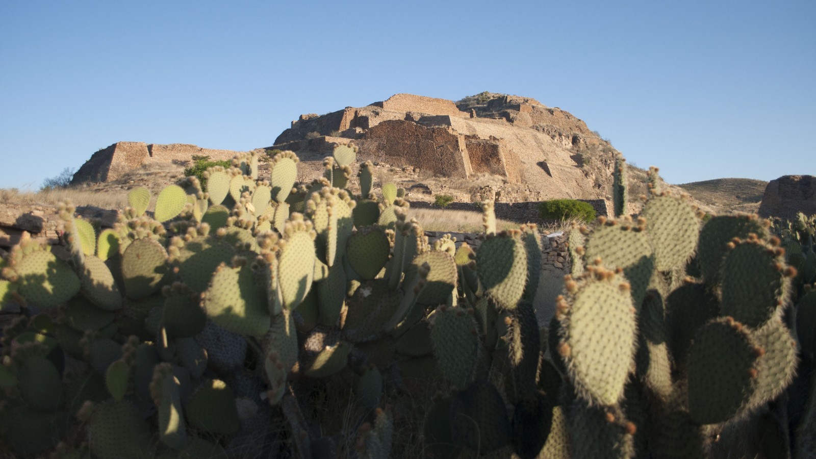
La Quemada contains structures far greater in size than any other archeological site in the region. For example, La Ciudadela (“The Citadel”), a complex surrounded by an 2,626 feet wall to the north, with walls measuring 20 feet in height and 13 feet in width; el Salón de las Columnas (“The Hall of Columns”), which extends over an area of 134 by 105 feet and may have had a roof 20 feet in height, or the Ballcourt, which at 262 by 49 feet is the largest in the area, with lateral walls of 10 and 16.5 feet in height. The Pirámide Votiva (“Votive Pyramid”) may be added to the list, with its sloping walls that are 33 feet in height, and the remains of a staircase which has collapsed at the top, where there used to be a temple. The housing areas consisted of a sunken courtyard with a temple overlooking them, like in Mesoamerica.

All of these structures were raised on platforms and terraces built on the hill of La Quemada, and the walls and columns are elegantly constructed with slabs of volcanic rock known as porphyritic rhyolite. In turn, these were coated with a clay stucco and possibly a mural decoration which has been completely lost, but can be deduced from other ancient pre-Hispanic cities. On some walls it is still possible to see the polished lime whitewash, whcih gives the city its overall appearance of elegance. 

Nowadays, we know that La Quemada was an urban pre-Hispanic settlement which controlled the Malpaso valley and extended its trade network to the canyons of Southern Zacatecas, the region of Tunal Grande, the Altos de Jalisco and part of present-day Guanajuato and Michoacán.

La_Quemada_6
INAH-Zona Arqueológica La Quemada
La_Quemada_10
INAH-Zona Arqueológica La Quemada
306011
INAH-FN
406338
INAH-FN
406343
INAH-FN
La_Quemada_11
INAH-Zona Arqueológica La Quemada
406350
INAH-FN
410289
INAH-FN
414593
INAH-FN
414594
INAH-FN
350 - 1000

Clásico Temprano a Posclásico Temprano
600 - 850

Clásico Tardío

Did you know...
  • At different times, the site has been known as Tuitlan, Chicomoztoc, Coalcamatl, Cerro de los Edificios and La Quemada.
An expert point of view
Carlos Alberto Torreblanca Padilla
Centro INAH Zacatecas
Archeological site
La Quemada
Practical information
Monday to Sunday from 09:00 to 18:00 hrs.

$80.00 pesos


  • Extra fee for video cameras
  • Discount for senior Mexican citizens
  • Discount for Mexican students and teachers
  • Sundays free for Mexican citizens
  • No Smoking
  • No entry with food
  • Pets not allowed
Se localiza a 56 km al sur de la ciudad de Zacatecas.

From the city of Zacatecas, take Federal Highway 54 Zacatecas-Guadalajara, for the municipality of Villanueva. The junction for La Quemada is on this road (It is signposted as "Ruinas de Chicomoztoc"). The entrance booth to the archeological zone is located at km 2.5.

Services
  • Estacionamiento
  • Sanitarios
GUIDE
Guide
Directory
Responsable
Carlos Alberto Torreblanca Padilla
This email address is being protected from spambots. You need JavaScript enabled to view it.
+52 (492) 923 1393
Encargada del Museo Arqueológico
María Guadalupe Tapia Hurtado
This email address is being protected from spambots. You need JavaScript enabled to view it.
+52 (045) 492 544 8450
1899
199_A_000
La_silueta_de_los_monumentos_de_La_Quemada_bajo_el_cielo_nocturno,_otra_perspectiva_visual_del_sitio_arqueologico_Foto_Juan_Carlos_Basabe_INAH-Zacatecas
Juan Carlos
Zona_Arqueologica_de_La_Quemada,_Zacatecas_Foto_Juan_Luna
Juan Luna
La_Quemada_es_una_de_las_urbes_prehispnicas_ms_grandes_del_norte_de_Mxico,_junto_con_Paquim,_en_Chihuahua,_y_Cerro_de_Trincheras,_SonoraFot
INAH-DMC/Héctor Montaño
Zona_Arqueologica_de_La_Quemada,_Zacatecas_Foto_Lariza_Cardenas
Lariza Cárdenas
La_Quemada_Foto_Mauricio_Marat_INAH
INAH-DMC/Mauricio Marat
A_travs_de_un_convenio_de_colaboracin,_el_Gobierno_de_Zacatecas_entreg_la_custodia_del_recinto_al_INAH_Foto_Mauricio_Marat_INAH_1
INAH-DMC/Mauricio Marat
A_travs_de_un_convenio_de_colaboracin,_el_Gobierno_de_Zacatecas_entreg_la_custodia_del_recinto_al_INAH_Foto_Mauricio_Marat_INAH_2
INAH-DMC
LA_QUEMADA
INAH-DMC/Héctor Montaño
La_Quemada_es_una_de_las_urbes_prehispnicas_ms_grandes_del_norte_de_Mxico,_junto_con_Paquim,_en_Chihuahua,_y_Cerro_de_Trincheras,_SonoraFot1
INAH-DMC/Mauricio Marat
Zona_Arqueologica_de_La_Quemada,_Zacatecas_Foto_Antonio_Ambriz_
Antonio Ambriz
Norte
Su origen sigue siendo un misterio. Algunos autores lo asocian con Chicomóztoc, mítico lugar por el que habrían pasado los aztecas en su peregrinación hacia el Valle de México. Poderoso centro rector, logró concentrar 220 asentamientos y tiene una arquitectura muy relevante.
Its origin remains a mystery. Some authors associate it with Chicomoztoc, a mythical place that the Aztecs passed through on their way to the Valley of Mexico. A powerful center of government, at its height it governed over 220 settlements and produced very distinctive architecture.
Recibe este nombre por los terrenos de la Hacienda de La Quemada, o bien, porque el término hace referencia a los restos quemados que fueron encontrando las personas que acudían al lugar a extraer piedra para la construcción de la hacienda.
Gets its name from the land of the Hacienda La Quemada, or rather, the term refers to the charred remains that were found by the people who went there to extract stone in order to build the hacienda.

LEGAL NOTICE

The contents of this website belong to the Instituto Nacional de Antropología e Historia de México, and may be downloaded and shared without alterations, provided that the author is acknowledged and if is not for commercial purposes.

Footer MediatecaINAH

Guardar
Lugares INAH

Idioma