


El Meco
(The monkey) The name of the site was the nickname of a local resident in the 19th century, it refers to malformation of his legs.
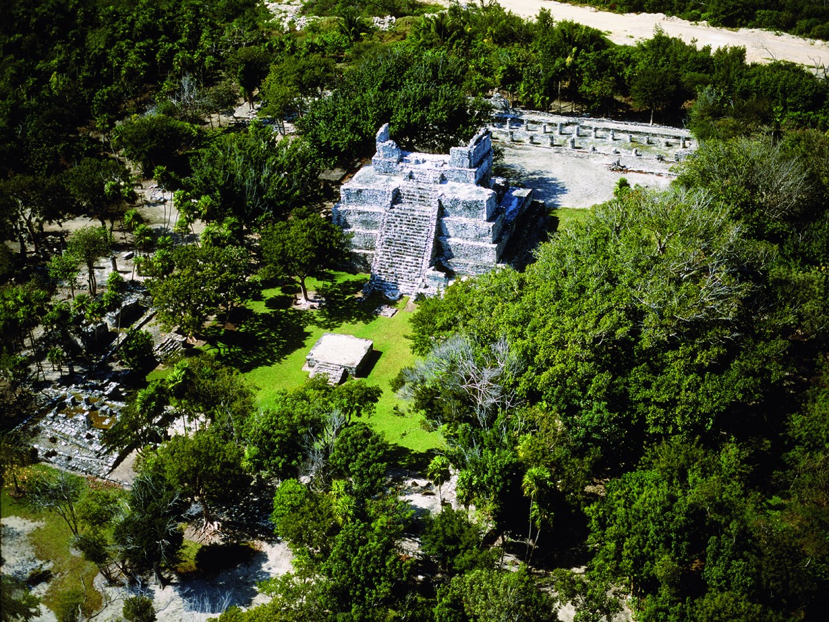
Situated on the coast, it probably played an important role in the navigation routes of the Maya. From the top of the highest building of the zone, known as "El Castillo," there is fine view of Cancun and the surrounding area.
About the site
Archeologists have found that El Meco was possibly inhabited from the third century AD, initially as a small fishing settlement which was later abandoned, and then reoccupied in the eleventh century. The coast of Quintana Roo was heavily populated in this period, perhaps by people arriving from the larger cities in the interior of the peninsula.
The inhabitants in the Postclassic period made the most of the strategic location of this place and turned it into a thriving city. This led to significant population growth and strengthened El Meco’s economic and possibly its religious standing, which was associated with the rituals held on Isla Mujeres, just across a stretch of the Caribbean from the site.
Allan Ortega’s bio-anthropological research on the skeleton collections amassed over a number of years from the excavations by Luis Leira, Elia Trejo and Enrique Terrones showed that the people of El Meco were from a single ethnic group, and were essentially local. The population was well-fed and compared to other contemporary groups on the east coast of Quintana Roo, the people were healthy, probably as a result of the great variety of marine resources available to them.
It is presently possible to visit the principal sector of the site, which includes the civic and ceremonial plaza, dominated by El Castillo (“The Castle”). On either side there are two small later buildings, which may have functioned as altars or minor temples.
Like sites of a similar style, this group includes other buildings with columns supporting flat roofs and which, given their dimensions, were probably set up as administrative areas in which officials could serve the various needs of the population. In some cases small temples for everyday worship stand alongside these buildings.
One of these temples, which encloses the north side of the plaza, is especially notable for the presence of a beautiful copo (fig) tree, which has grown from inside the building giving it a very distinctive appearance. The main plaza of El Meco has a small shrine in the center where offerings were left during ceremonies and dances.
The archeological site was bisected by the highway built in the 1970s to link the tourist center of Cancun with the towns to its north. This left the civic and public area described above in one sector while the jetty and the residential buildings near the beach were left in another sector, yet to be excavated, which explains why it has yet to be opened to the public.
Did you know...
- In 2005, the passage of Hurricane Wilma through the region blew down a large number of trees on the site. However, the INAH worked on an intense reforestation program that allowed the original appearance to be restored.
An expert point of view

Adriana Velázquez Morlet
Centro INAH Quintana Roo
Practical information
Monday to Sunday from 08:00 to 17: 00 hrs. Last entry 16:30 hrs.
$75.00 pesos
Derivado de los trabajos del Programa de Mejoramiento de Zonas Arqueológicas (Promeza), en el marco del Proyecto Tren Maya, la zona arqueológica permanecerá cerrada hasta el 29 de febrero del 2024
Se localiza al norte de la ciudad de Cancún, Quintana Roo.
From the city of Cancun, take the Puerto Juárez-Punta Sam highway. The site is located 2.7 km ahead.
Services
-
+52 (983) 837 24 11
-
This email address is being protected from spambots. You need JavaScript enabled to view it.
Directory
Encargado de la administración de la Zona Norte
Williams Ferneli Tun Cab
This email address is being protected from spambots. You need JavaScript enabled to view it.


