


Las Labradas
The name of the site derives from the number of stone carvings found on boulders on the shore.
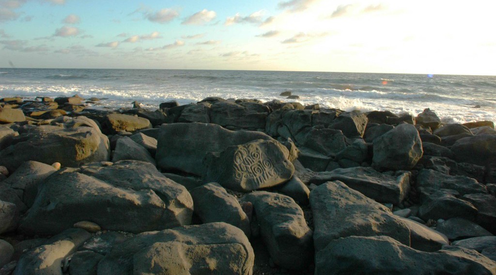
An extraordinary testimony to the ancient inhabitants, unique not only because of the beach location, but because of the more than 700 rock carvings on volcanic boulders. The motifs of plants, flowers, animals and geometric figures are undamaged by the sea.
About the site
This archeological site, bordered by dense mangrove trees, is located on an area of the beach containing basaltic rocks of volcanic origin. More than 700 carvings have been made here, depicting humans, animals, plants and geometric figures.
Since 2009, the INAH has been carrying out continuous research into the engravings and the cultures which settled in the region during the pre-Hispanic era. More than 20 settlements have been identified thanks to the archeological studies carried out in the surrounding areas. In principle, the existence of a pre-ceramic occupation (7000-5500 BC) was discovered. This arose before farming began on the American continent and is characterized by a stoneworking industry in which leaf-shaped arrowheads are found (Lerma style). Another settlement was established much later, with the presence of ceramic and other archeological materials corresponding to a sedentary culture (Chicayota culture) linked to the Aztatlán tradition (750-1250).
Las Labradas is the first archeological settlement open to the public in Sinaloa. It was declared a zone of archeological monuments on November 30, 2012. Its engravings are found on the surface of the rocks as individual figures or as panels (of two or more figures). Furthermore, they are not distributed in a defined pattern. Some of them are concentrated in groups or sets and others are isolated, although the cause of this distribution is mostly due to the physical characteristics of this same grouping.
Manufacturing techniques include abrasion and percussion. Low-relief and high-relief motifs are frequent, together with the simple removal of the upper layer of the rocks. These are of many different sizes and are distinguished by their smooth and polished surface, rounded by the sea. They also have a dark and opaque color, presenting various different tones of grey over the course of the day. Additionally, large quantities of pebbles are present, the products of a geological event which took place thousands of years ago.
At least nine rock engravings exist which have some sort of spatial and, in some cases, numerical connection. These are related to the four cardinal points, the solar elements and the proximity to the imaginary line of the Tropic of Cancer. This is the case with one of the largest rocks at the start of the path from the entrance to the archeological site. A double contoured cross inside a rectangle can be seen on it, which represents the four directions or cardinal points.
Similarly, a celebration of the summer solstice seems to be symbolically represented in Las Labradas. The solar elements depicted in the geometric figures and in the majority of the human characters suggest the presence of an ancient pre-Hispanic world view. In the majority of the engravings, the sun is replicated as the center, origin and point of convergence (in its spatial and geometric aspect), as light, fire, heat and wave movement (in its natural aspect) and as an object of contemplation, worship, exaltation and transformation (in its metaphysical aspect).
It is also possible to observe various petroglyphs along the route which represent characters with circular and triangular heads, open or raised arms and completed or half-completed bodies. There are also some showing only a face. Some figures have no hair and others have a range of spiked hairstyles. Sometimes, there is a small line for a mouth, while the nose is represented in only very few cases.

INAH-FN
View of several petroglyphs on a rock, Las Labradas

INAH-FN
Petroglyph with frets, rhomboids and spirals, Las Labradas

INAH-FN
Petroglyphs with geometric designs in Las Labradas

INAH-FN
Petroglyphs with spirals and circle, Las Labradas

INAH-FN
Zoomorphological petroglyph at Las Labradas

INAH-FN
Petroglyphs with spirals at Las Labradas beach, detail

INAH-FN
Overview of the petroglyphs at Las Labradas

INAH-FN
View of petroglyph in Las Labradas with various geometric designs

INAH-FN
Lateral view of petroglyphs showing two anthropomorphic beings, Las Labradas
Did you know...
- Las Labradas is a unique site in the American continent due to its geological, natural and cultural characteristics.
- Since 2012, the Mexican government has been promoting the archeological site to encourage UNESCO to list it as a World Heritage Site.
- The ancient inhabitants made the most of the natural formation of the rocks. In fact, there are many representations of faces on the corners, which is characteristic of this archeological site.
Practical information
Monday to Thursday from 08:00 to 17:00 hrs. Friday to Sunday from 08:00 to 18:00 hrs.
$95.00 pesos
Se localiza en la franja costera del municipio de San Ignacio, en el sur del estado de Sinaloa, a 51 km al norte de Mazatlán y a 29 km al norte del Trópico de Cáncer.
From Mazatlan, take the Mazatlán-Culiacán highway towards the town of La Chicayota; at km 51 (approximately 40 minutes), take the return to follow the dirt road until you reach La Chicayota. At the western end of the village, locate the train track and follow the road; continue on the right, passing under the bridge. After one last turn to the left, follow the straight road to the coast. The distance between La Chicayota and Las Labradas is 2.5 km.
From Culiacán, take the Mazatlán-Culiacán highway and follow the indications above from the return located at km 51 (approximately two hours).
From Culiacán, take the Mazatlán-Culiacán highway and follow the indications above from the return located at km 51 (approximately two hours).
Services
-
This email address is being protected from spambots. You need JavaScript enabled to view it.
-
FACEBOOK
-
TWITTER
Directory
Encargado de la Zona Arqueológica
Leonardo Palazuelos Osorios
This email address is being protected from spambots. You need JavaScript enabled to view it.
+52 (667) 713 92 52 y 7521541, exts. 338009 y 338000


