


Lagartero
(Place of lizards) Gets its name from the abundant population of crocodiles that inhabited the swamps.
John Lloyd Stevens described it as “a wild place of incomparable beauty…” The great civic and religious center is located on the island of El Limonal (lemon grove) and the rest of the vestiges are dispersed on little islands and peninsulas in present-day Lagos de Colón.
About the site
The part of southeast Chiapas where the El Lagartero archeological site is located has a series of islands, lakes and streams surrounded by forests. The site is in the ejido of Lagos de Colón, in the Municipality of La Trinitaria, at the foot of the Sierra de los Cuchumatanes very close to the Guatemala border.
The area was settled from the early Classic (300) until the Late Postclassic (1400). However it reached its peak in the Late Classic (700-900), which can be seen from the architecture and from the polychrome codex style ceramics; and this is why the city may be considered the great civic-religious center of the region. A large part of the archeological site is on small islands and peninsulas jutting out into the lakes, on the islands of Cangrejo, El Sabino, Hasam, Puente de Mora and El Búho. There are also reports of mounds making up small plazas and well-preserved structures on small unnamed islands.
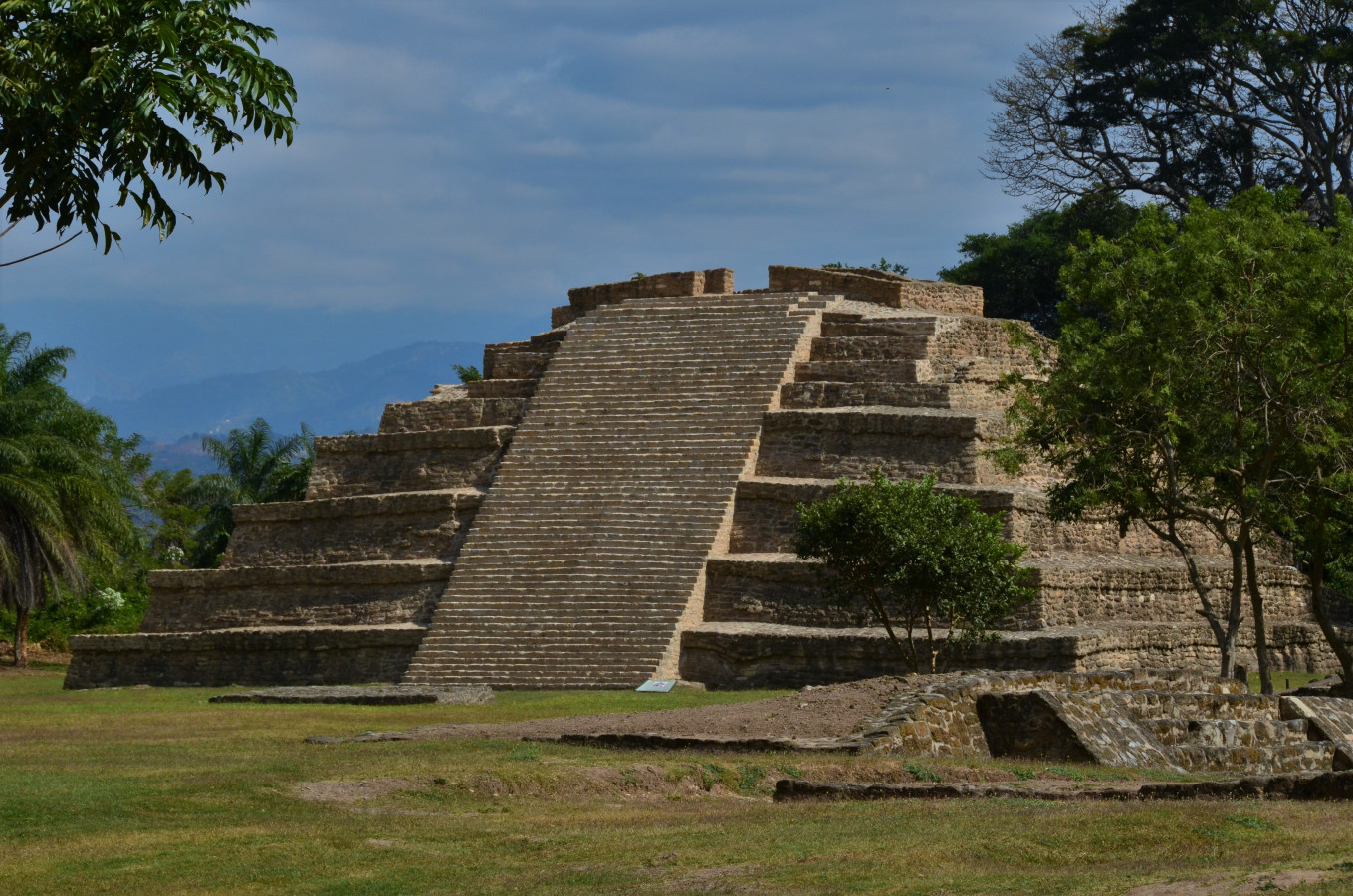
The largest island, El Limonal, has the site’s central area. The island is in an area of lakes and swamps which are fed by springs as well as by the rivers Lagartero and San Lucas, upper tributaries of the Grijalva River. The underlying rock is limestone, which gives rise to a varied karst topography of crater shaped depressions, sinkholes and fissures. The vegetation is an exuberant type of scrubby forest. The plinths for each dwelling form courtyards, and the highest concentration of these is in the south part of the island. The core ceremonial area is at the north end of the island. It has altars, some small structures and six large ones: pyramids 1, 2, 3 and 4, a ballcourt and a great platform.
The main buildings include more than 15 pyramids, the largest of which is 40 feet high. There are also open and closed plazas, as well as isolated and interconnected platforms of different sizes. Plazas were defined by their civic and religious structures, while residential buildings stretched out along the lakes. Stone extracted from cenotes was used for construction, and being porous and soft, it was easy to work, but also eroded and disintegrated easily, which is why few temples made from this stone have survived. The ancient inhabitants of El Lagartero lived by farming corn, beans and other plants and marine species.
The area was settled from the early Classic (300) until the Late Postclassic (1400). However it reached its peak in the Late Classic (700-900), which can be seen from the architecture and from the polychrome codex style ceramics; and this is why the city may be considered the great civic-religious center of the region. A large part of the archeological site is on small islands and peninsulas jutting out into the lakes, on the islands of Cangrejo, El Sabino, Hasam, Puente de Mora and El Búho. There are also reports of mounds making up small plazas and well-preserved structures on small unnamed islands.
The largest island, El Limonal, has the site’s central area. The island is in an area of lakes and swamps which are fed by springs as well as by the rivers Lagartero and San Lucas, upper tributaries of the Grijalva River. The underlying rock is limestone, which gives rise to a varied karst topography of crater shaped depressions, sinkholes and fissures. The vegetation is an exuberant type of scrubby forest. The plinths for each dwelling form courtyards, and the highest concentration of these is in the south part of the island. The core ceremonial area is at the north end of the island. It has altars, some small structures and six large ones: pyramids 1, 2, 3 and 4, a ballcourt and a great platform.
The main buildings include more than 15 pyramids, the largest of which is 40 feet high. There are also open and closed plazas, as well as isolated and interconnected platforms of different sizes. Plazas were defined by their civic and religious structures, while residential buildings stretched out along the lakes. Stone extracted from cenotes was used for construction, and being porous and soft, it was easy to work, but also eroded and disintegrated easily, which is why few temples made from this stone have survived. The ancient inhabitants of El Lagartero lived by farming corn, beans and other plants and marine species.
Did you know...
- A stela, which is around one thousand year old, was found in late 2009. In bas-relief, it shows the transfer of power between two Mayan groups.
- The remains of two large earthenware pots were found at the top level of Pyramid 4, and near these there was a black vessel with a zoomorphic cover which contained rich jadeite offerings, most notably ear flares, a jointed turtle and necklace beads.
- Four incomplete alligator heads confirm that the site was originally named after the reptile, which was a symbol of the underworld for the Maya.
- Ceramics and remains of textiles were found in the ossuary, as well as copper pendants, a copper rattle and an amber ear flare.
Practical information
Temporarily closed
Monday to Sunday from 8:00 to 17: 00 hrs
$75.00 pesos
Se localiza en el islote el Limonar en la zona lacustre Lagos de Colón, municipio de La Trinitaria.
From the city of Comitán take highway 190 to Ciudad Cuauhtémoc and at kilometer 57, before reaching the San Gregorio Chamic bridge, take the exit that leads to the Cristóbal Colón ejido. The archeological zone is 1.5 kilometers from the Lagos de Colón ejido, after crossing the Lagartero River.
Services
GUIDE

-
+52 (961) 612 2824, +52 (961) 612 8360
-
This email address is being protected from spambots. You need JavaScript enabled to view it.
Directory
Encargado de Operación del Sitio
Gabriel Lalo Jacinto
This email address is being protected from spambots. You need JavaScript enabled to view it.
+52 (961) 612 2824, exts. 168000 y 168001


