


The pre-Hispanic settlement of Chicanná is small in scale and the constructions in its central area are distributed in small groups. The water supply for its former inhabitants might have been obtained from the nearby springs, or through the use of specially made rainwater collection chambers called “chultunes”. The ridges and terraces on the local hills reveal a specialized form of intensive agriculture.
Human occupation at the site in question can be traced back to the Middle Preclassic (before 200 BC) and the Late Preclassic (150 BC – c. 250 AD) periods, and continued until around 1100 AD. It flourished in the Late Classic (550-700 AD) and Early Postclassic (700-1100/1200 AD), although there are some traces of residual habitation belonging to the Late Postclassic (after the year 1200).
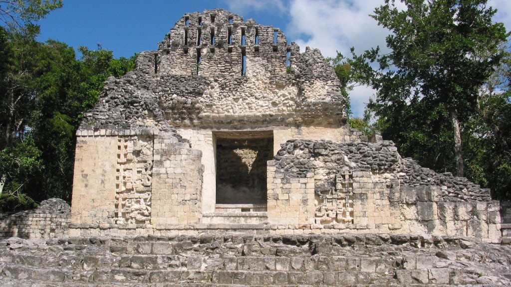
In the Yucatecan Mayan language, Chicanná means “the house of the serpent’s mouth," referring to the snake-like decorative features on some of the buildings. A few of the main structures stand out for the profusion of their ornamentation, with zoomorphic facades representing Itzamná with open jaws, as found in Buildings II and XX. Meanwhile, stucco masks in profile flank the main entrances of structures such as Buildings X and VI. Another distinctive feature are the towers on each side of a low, elongated building, as in the case of Building 1, which is a hallmark of the Río Bec region’s architecture and pottery. It is important to bear in mind that various buildings on the site are the result of more than one phase of construction.
Pottery found in Chicanná dating from the Middle and Late Preclassic periods provide relatively meager evidence of its occupation at that time. However, by the Early Classic, building activity clearly gathered momentum as seen in the stucco floors on Plaza A and the Structures IIIsub-2 and XISub, associated with the ceramics of the Sabucan complex (450-500 AD).
It was not until the beginning of the Late Classic that Building IIIsub-1 at the center of the settlement, the central part of Building I (without its towers), Structure VI, as well as Buildings VII, X and XI were all erected. Towers were added to Building I toward the end of the Late Classic, and Structure II was built, as well as the west annex of Structure VI and the first level of Structure XX. The building work did not stop in the Late Postclassic, because this is when Structures III and IIIA were built, as well as the east annex of Structure VI and the upper level of Structure XX.
The archeological site of Chicanná is located in the south of the state of Campeche, at kilometer 143 of the federal highway that runs between Escárcega and Chetumal. It was discovered by Jack D. Eaton during the early explorations for the Southeast Campeche project led by Tulane University’s Edward Wyllys Andrews IV, under the auspices of the National Geographic Society, from 1969 to 1971. He also excavated and consolidated large sections of Buildings II and XI.
Research and restoration in the area increased beginning in the 1980s. However, in each case the buildings were only partially excavated. During this period Román Piña Chan and his team focused on Structures I and XX, Ramón Carrasco Vargas on Buildings III, VI, XX and the annex of Building XVII, and Ricardo Bueno Cano cleared and consolidated Structures X, XI and the rear façade of Structure II during the 1992 and 1993 seasons.
Recently, between 2011 and 2015, INAH’s regional office in Campeche carried out work in Chicanná as part of its program of small and large-scale projects at archeological sites open to the public, under the supervision of Vicente Suárez Aguilar. About a dozen pre-Hispanic buildings benefitted through a three-pronged approach: architectural maintenance and conservation to repair damage from human and natural causes; additional work to clear and restore buildings already partially explored some years ago; and, finally, a comprehensive excavation of buildings that complement the building sequence and contribute additional information about human habitation of the site (chronology, cultural relations, and so on).

- Chicanná is believed to have been a center for the rulers of the Río Bec region during the Classic period.
- The site’s pre-Hispanic center consists of five monumental building complexes; construction work on them began at the dawn of the Common Era.
- The most prominent pre-Hispanic structures are richly decorated, with stucco masks on their main façades, reflecting the ideological complexity of the ruling elite.


-
+52 (981) 816 8179
-
This email address is being protected from spambots. You need JavaScript enabled to view it.
-
FACEBOOK
-
TWITTER


