


Chimalhuacán
Place where there are shields
Seven and a half centuries ago, three Chichimeca lords arrived in Chimalhuacán (abandoned since the fall of Tula), and re-founded a city which became a great Acolhua capital. As a testimony they left the Tecpan, the superb palace of their Tlatoani (chief), and a great number of excellent sculptures, which was their main activity.
About the site
Chimalhuacan has the best-preserved palace in the basin of Mexico. There have been several archeological excavations at this site, which have allowed us to define different aspects of both its architecture and the sequence in which it was constructed, the latter being linked to numerous Chichimeca groups who arrived in the basin after the twelfth century.
It was founded in approximately 1259, in a manner similar to other places in the area at this time, such as Tenayuca, Texcoco, Azcapotzalco, Cuautitlan, Chalco, Xaltocan and Tenochtitlan.
The first excavation was made in 1943 by the archeologist Eduardo Noguera at the site known as El Tepalcate. Later, Ángel García Cook investigated the lake bed on the northern side of the Chimalhuaque hill in the early 1970s. A decade later, Jeffrey Parsons visited a large part of the Texcoco area and located most of its archeological sites. Thanks to Parsons, we now know that Chimalhuacan became the heart of one of the four demographic and political cores that existed in this area.
Archeological explorations have also allowed us to determine the different periods of this ancient pre-Hispanic city: Late Formative (400-1 BC), Early Classic (150-300 AD), Classic (600-800 AD), Early Postclassic (800-1100 AD), Middle Postclassic (1200-1430 AD) and Late Postclassic (1430-1521 AD).
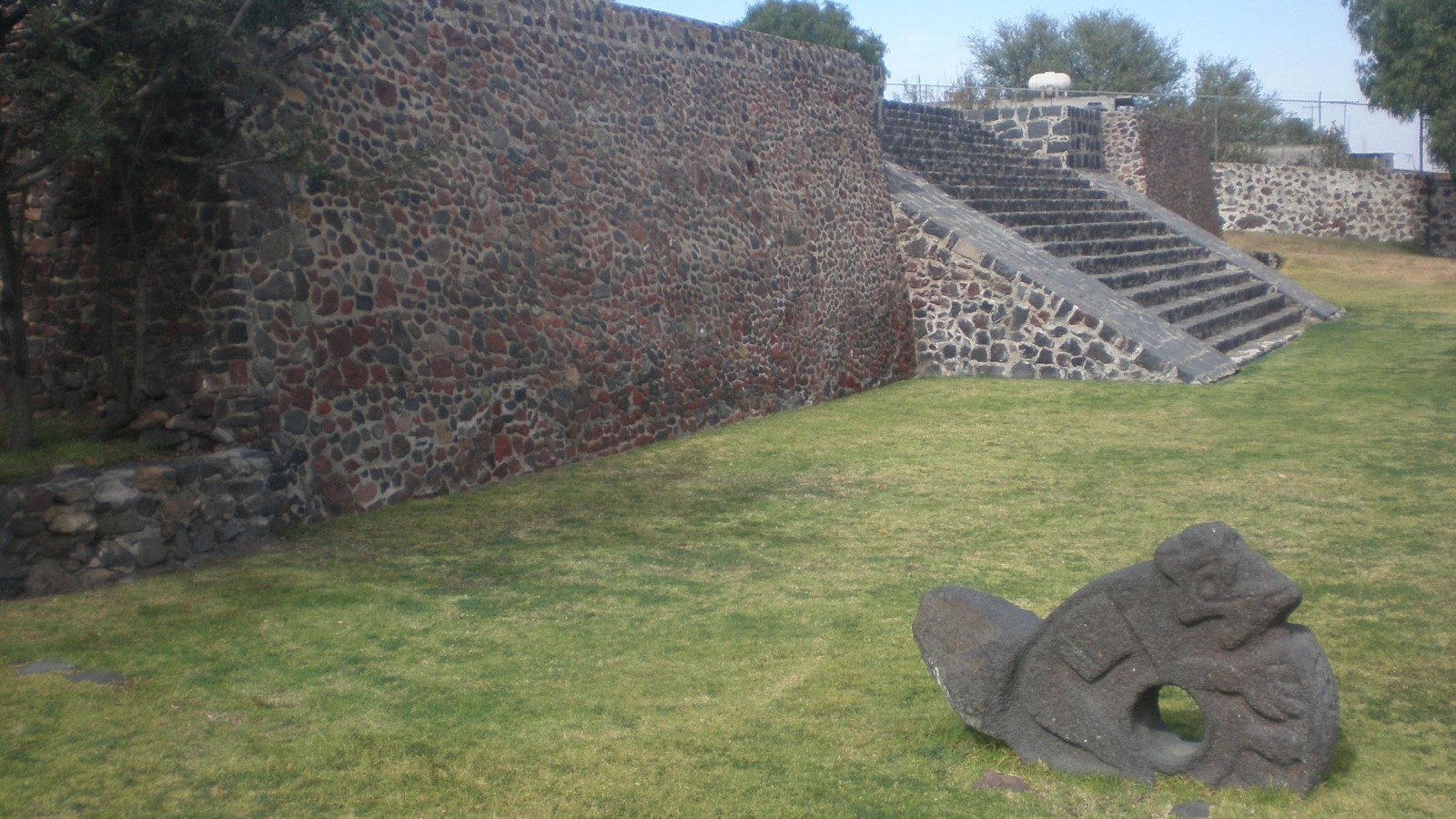
We believe that a residential zone was built during the Late Postclassic, which corresponds to the Toltec hegemony. However, given that this first structure is beneath the current one, we have not been able to determine its shape. It is possible that most of the center of the altepetl (city-state) is beneath the town and surrounding areas. The archeological zone is therefore limited to the tecpan or palace of Chimalhuacan. This magnificent structure consists of a large rectangular platform oriented east-west, on which residential areas were constructed. There is still evidence of these, such as the bases of walls, floors and other architectural elements.
As the rooms were in the highest part of the building, not only could all of the surrounding landscape be observed from them, but they became a symbolic landmark indicating their occupants’ status. It is possible that visitors were received by the ruler of Chimalhuacan and provided with accommodation at the top of the tecpan.
In the wake of the Conquest, the Spanish partially destroyed this building and built a small chapel, found during the explorations performed by Ángel García Cook in 1966. Oral tradition identifies this church as the Chapel of San Andrés Apóstol (Saint Andrew the Apostle), the first site of Christian worship in this town in the sixteenth century. The bases of its entrance columns remain, as do part of the side walls.
It was founded in approximately 1259, in a manner similar to other places in the area at this time, such as Tenayuca, Texcoco, Azcapotzalco, Cuautitlan, Chalco, Xaltocan and Tenochtitlan.
The first excavation was made in 1943 by the archeologist Eduardo Noguera at the site known as El Tepalcate. Later, Ángel García Cook investigated the lake bed on the northern side of the Chimalhuaque hill in the early 1970s. A decade later, Jeffrey Parsons visited a large part of the Texcoco area and located most of its archeological sites. Thanks to Parsons, we now know that Chimalhuacan became the heart of one of the four demographic and political cores that existed in this area.
Archeological explorations have also allowed us to determine the different periods of this ancient pre-Hispanic city: Late Formative (400-1 BC), Early Classic (150-300 AD), Classic (600-800 AD), Early Postclassic (800-1100 AD), Middle Postclassic (1200-1430 AD) and Late Postclassic (1430-1521 AD).
We believe that a residential zone was built during the Late Postclassic, which corresponds to the Toltec hegemony. However, given that this first structure is beneath the current one, we have not been able to determine its shape. It is possible that most of the center of the altepetl (city-state) is beneath the town and surrounding areas. The archeological zone is therefore limited to the tecpan or palace of Chimalhuacan. This magnificent structure consists of a large rectangular platform oriented east-west, on which residential areas were constructed. There is still evidence of these, such as the bases of walls, floors and other architectural elements.
As the rooms were in the highest part of the building, not only could all of the surrounding landscape be observed from them, but they became a symbolic landmark indicating their occupants’ status. It is possible that visitors were received by the ruler of Chimalhuacan and provided with accommodation at the top of the tecpan.
In the wake of the Conquest, the Spanish partially destroyed this building and built a small chapel, found during the explorations performed by Ángel García Cook in 1966. Oral tradition identifies this church as the Chapel of San Andrés Apóstol (Saint Andrew the Apostle), the first site of Christian worship in this town in the sixteenth century. The bases of its entrance columns remain, as do part of the side walls.
400 a.C. - 1521
Preclásico Tardío a Posclásico Tardío
1100 - 1521
Clásico Tardío a Posclásico
Map

Did you know...
- The name of this archeological zone comes from Nahuatl and is related to the Chimalhuaque hill, which looks like a shield lying on its side from various lakeside viewpoints.
- The tecpan (palace) was not only the residence of the tlatoani (ruler), but was also a space for administrative and political activities.
Practical information
Temporarily closed
Tuesday to Sunday from 10:00 to 17:00 hrs
Free entry
Se localiza en la calle de Pochotes s/n, Barrio de San Andrés, Chimalhuacán, Estado de México, a espaldas de la presidencia municipal de Chimalhuacán.
From Mexico City, take Federal Highway 190 Mexico-Texcoco, until you reach the exit for Chimalhuacán. The site is behind the Town Hall.
Services
-
+52 (722) 167 1325
-
This email address is being protected from spambots. You need JavaScript enabled to view it.
Directory
Responsable
Raúl Ernesto García Chávez
This email address is being protected from spambots. You need JavaScript enabled to view it.
+52 (722) 21 39 581


